The blog post below is a brief overview about the Blueway Trail following the meeting held on April 27th at the STEM Education Center in West Palm Beach.
At this meeting were updates for those from the public and organizations interested in the future Blueway Trail via the C-51 Canal, bypassing the S-155 Spillway structure, creating more access for the public between the Inland Chain of Lakes and the Intracoastal (Lake Worth Lagoon). This meeting was widely noticed including being announced on this blog (click on this link to read the meeting notice).
Briefly, a recap for those of you unfamiliar
with this exciting project:
The vision for the Chain of Lakes Blueway Trail experience is to finally link Palm Beach County waterways by providing two-way access for small boats and non-motorized watercraft [to and from the Intracoastal] . . . In Palm Beach County, 80 percent of registered small boats meet this criteria — and that doesn’t include the thousands of kayakers, paddleboarders, canoers and others who use the local waterways every year.
This short video has more information:
One more thing before we continue about the Blueway Trail Inc. meeting this week. Besides the City of Lake Worth having a resolution of support for the future Blueway Trail here are others who have shown their support as well:
- City of Boynton Beach.
- City of Greenacres.
- Town of Lake Clarke Shores.
- City of Riviera Beach.
- Town of Haverhill.
- Town of Hypoluxo.
- Town of South Palm Beach.
Now let’s continue. . .
In August 2017 when the Blueway Trail group met the focus had turned to identifying the parties or entities which would be responsible for the operation and management of a combination kayak/canoe path, fishing pier and eventually a boat lift operation in Spillway Park (located in the City of Lake Worth). That responsibility seemed likely to fall to Palm Beach County. However, in formal and informal discussions with the County, there did not seem to be any interest from the County to play such a role.
In this view is the C-51 Canal.
West Palm Beach is to the north and Lake Worth to the south. Spillway Park and the S-155 Spillway structure are indicated in the yellow box (click on map to enlarge).
West Palm Beach is to the north and Lake Worth to the south. Spillway Park and the S-155 Spillway structure are indicated in the yellow box (click on map to enlarge).
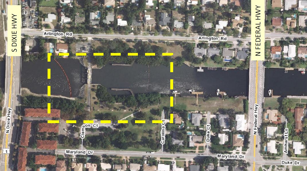 |
| To visit Spillway Park in the City of Lake Worth take Maryland Dr. off Federal Hwy. to the park entrance at the end of the road. |
Latest step forward: Formation
of Blueway Trail, Inc.
At last Friday’s meeting we learned more about a redirection and the establishment of a non-profit entity called Blueway Trail, Inc. This is a fully-formed and registered 501c3 organization with a board of directors and by-laws.
The Board of Directors is listed below.
Here is a view from the proceedings.
 |
| Some very familiar faces for those of you involved in politics and planning here in Central PBC. |
For example. . .
 |
| Lake Worth’s own inimitable resident Greg Rice and Shanon Materio, a long-time business owner in the City of Lake Worth and also a former commissioner in West Palm Beach. |
Going forward this organization will be able to receive grant monies from a variety of sources — both public and private — in the pursuit of recognition of the Blueway Trail on state “blueway” maps. The “Guidelines for a State Designated Paddling Trail” are at the end of this blog post.
Blueway Trail Inc., along with its “partners, trail friends and supporters” will also be able to create more interest in the re-establishment of fishing piers along the C-51 canal which were very popular with local fisherman. Fishing piers were once located along Spillway Park in the City of Lake Worth and on the northern side of the canal in West Palm Beach.
The idea of a mechanical boat-lift is now something of consideration in the future but remains a high priority for many supporters of the Blueway Trail, notably the communities of boaters west of the Spillway in the Town of Lake Clarke Shores and other towns and cities further west in Central Palm Beach County.
Cover letter from yesterday’s Blueway Trail Inc. meeting.
Click on letter to enlarge:
 |
| Blueway Trail Inc. Board of Directors: President Richard Pinsky, Vice Pres. Greg Rice, Secretary Aaron Wormus, Treasurer Daniel Clark, and directors Chuck Collins and Mark Hightower. |
Elected officials are excluded from being members on the board of Blueway Trail Inc. in order to avoid ethical and conflict of interest issues as the group seeks to raise money in order to meet its goals. The first step will be seeking official designation for the “Blueway Trail” that runs from Lake Ida to the south to the mouth of the Loxahatchee River to the north.
A map of all the blueway trails in the State of Florida was part of the meeting packet. The map below shows a surprising dearth of such “blueway” recreational areas in South Florida, especially inland west of the Atlantic Ocean coast.
Click on image to enlarge:
 |
| Just having an official designation of the “Blueway Trail” for inclusion on a state map would promote eco-tourism in Cental PBC and create more public interest, fundraising and future improvements, e.g., a boat lift bypassing the Spillway on the C-51 Canal. |
One of the first goals of Blueway Trail Inc. is to re-establish the fishing piers on both sides of the C-51 Canal east of the Spillway where wooden piers once existed for many years. Those have been removed due to their deterioration over time.
The preference would be to construct concrete piers closer to the water surface better suited for fishing and for the fish as well. The piers in place previously were too high above the water and the loud “Smack!” when fish were released was very unpleasant to hear and one would presume unpleasant for the fish as well. The former piers were also poorly designed. Often fish on the line would get stuck on the crisscrossed beams and die creating a very unpleasant smell around the piers.
New concrete fishing piers would have a life of fifty years or more rather than 8–10 years with wooden structures. The local fishing community here in Central PBC is very unhappy that one of the best and most well-known spots for snook fishing has been mostly inaccessible ever since those two fishing piers were removed.
“Stay Tuned” as they say for more information and updates about the Blueway Trail and the work being done by Blueway Trail Inc. Thank You for visiting today and hope you found this information helpful and stay tuned for more updates and information to come.
In conclusion, below is a quote from The Palm Beach Post which is soon to be taken over by GateHouse Media. It’s interesting to note that following this news report published twenty-eight months ago a nearly two year news blackout ensued during which time the Blueway Trail was ignored by the editor(s) at the Post even though they had a beat reporter assigned to cover the City of Lake Worth.
Before the first shovel is turned, several other government entities must agree to the project. But many of them stand to gain by it.
The mayor for one, Robert Shalhoub, of Lake Clarke Shores, told county commissioners before their vote on Dec. 15, “This is one of the strongest economic engines that can possibly be imagined.”
—Article dated Dec. 24th, 2015 titled, “Lift at spillway [Spillway Park in City of Lake Worth] would allow boat traffic from inland lakes to ocean”.
Minimum Guidelines for a State Designated Paddling Trail*
- A local, regional or state entity agrees to be the manager of the trail in terms of development and long-term maintenance. The manager must agree to monitor the trail at least once a year and clear up any logjams or other impediments as needed. A trail use plan shall be part of the agreement and an example can be provided.
- The trail has scenic, historical or other unique qualities that make it attractive to paddlers.
- The trail is at least three miles in length.
- There is adequate public access.
- Adequate information is provided in terms of difficulty, mileage, safety considerations and environmental conditions.
- Signage can help to identify a trail for its users and provide direction, especially in confusing areas, but is not required. GPS points on a clear map will suffice.
- Though desirable along many paddling trails, campsites and overnight stops are not required as long as public access points are less than 20 miles apart so paddlers can complete day trips in a reasonable amount of time.
*For more information contact Doug Alderson at 850-245-2061; email: dougalderson@dep.state.fl.us


![Dr. W. H. Cotton’s ode: “Oh, My Lake Worth, Florida!” [circa 1920].](https://blogger.googleusercontent.com/img/b/R29vZ2xl/AVvXsEjUL75cv6zJQFjX15ojOIIz9AjnbqH4asHJTYSDhnGnYr7rJZRha1NcNTirj2xPcId158vkz5Hw-wXgOfrlztj8Zr8jLFFCfuEN6PyV44ZlpMRmJ68xbtFL9vzxNiG7xDs_HJvm/s1600/LakeWorthPioneers.JPG)


