And once again The Palm Beach Post is reporting this incident occurred “west of Lake Worth”.
For many in the press and news media everything that happens in Central Palm Beach County is ‘west of Lake Worth’.
About this crash on 10th Ave. North in the Monday, Oct. 29th print edition of the Post in the LOCAL section “In Brief” the headline read “LAKE WORTH”. In the online edition it read “[W]est of Lake Worth”.
The location of this incident should have been reported as near the Village of Palm Springs or in Palm Springs. Until further details are released from PBSO we will not know for certain. Here is an excerpt from the news report in the Post:
Authorities didn’t release the precise location of the accident. 10th Avenue is the dividing line [emphasis added] between Palm Springs to the north and an unincorporated area to the south.
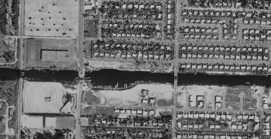
As you can see in the map below, the municipal limits of Palm Springs (shaded blue) do indeed go south of 10th Ave. North, what the Post reports as the “dividing line” (see map below).
The incident occurred east of Congress Ave. and well west of Lake Worth (shaded green). The Keller Canal is the western border of the City of Lake Worth.
Click on image to enlarge.
Unshaded areas are unincorporated PBC:
Unshaded areas are unincorporated PBC:
 |
| How long did it take to discover this information? About one minute. Continue reading to learn how. |
Ever heard of the Geo Nav mapping tool provided by the PBC Property Appraiser? Learn more about that tool below which has multiple layers of information. After a few tries, in just moments, tons of information will be available. This mapping tool is extremely helpful in many fields including those in public relations, the real estate business, and press and news media to quickly see the location of an incident and nearby landmarks and whether it’s in a municipality. Or not.
But still too many reporters are too slow to pick up on this new mapping tool.
For example see another map below. Just by clicking on the “County Parks” tab the County’s John Prince Park shows up as light green. Use the municipal parks tab and every park within a municipality will appear. Click on the “Municipalities” tab and each municipality shows up a different shade of color.
The areas not shaded? Those are unincorporated areas in Palm Beach County, suburban Lake Worth, John Prince Park (site of recent plane crash) and the PBC Park Airport are all in unincorporated PBC.
Also of note the PBC Park Airport is not in the Town of Lantana but some still refer to it as the ‘Lantana Airport’. The nearest municipality is the City of Atlantis just west of Congress Ave.
Click on image below to enlarge.
See the legend in the top left?
Go to the Geo Nav mapping tool and click on
“Layers” tab (far left) and have fun!
“Layers” tab (far left) and have fun!
 |
| Take a few moments today and check out the Geo Nav mapping tool. It will come in handy. Especially when verifying press and news media reports. |


![Dr. W. H. Cotton’s ode: “Oh, My Lake Worth, Florida!” [circa 1920].](http://1.bp.blogspot.com/-yhHyCn84ZIQ/WezjlEL-0tI/AAAAAAAAPZ4/CzkhriK6zpEJJ3d9Je1495d49gIhnMlxACK4BGAYYCw/s1600/LakeWorthPioneers.JPG)