Don't forget that older posts are available via the search function - upper left corner, through clicking on the topic tabs on the right hand side of the page and by clicking on the date further down the page.
Here are a series of comparisons with other beach areas in South Florida. The selections here include South Florida communities where the mainland downtown street leads to an ocean beach area. Besides Lake Worth, I have chosen Delray Beach and Fort Lauderdale as examples. These weren't chosen as places to emulate -hardly-, but to show how positively the current Greater Bay site plan compares with geographically similar situations.
(remember, if you would like to see greater detail, just click on the image)

I always think it's a good idea to remind ourselves that we are part of the greater South Florida Urbanized Mass (SFUM) of 5,000,000 people. The picture above shows that better than any - and it only shows a portion of the SFUM. This reminds us that we are already part of an ecologically disturbed and urbanized environment. Lake Worth has an area of about 5 miles by 5 miles and we have a population of 40,000 - a very small potion of the total SFUM. Where the City has waterfront - either Lake Worth or the Atlantic Ocean - a considerable amount is under the City's control.
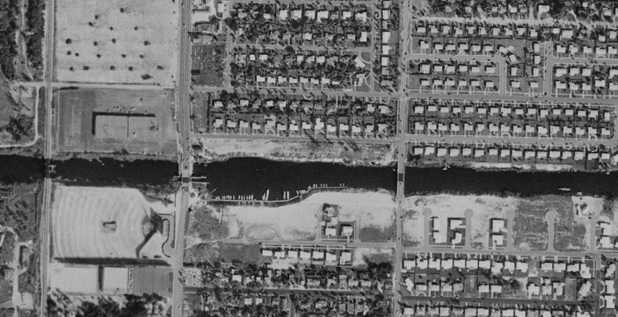
 The above picture is of the Lake Worth municipal beach and vicinity from about 2300 ft. A couple items are interesting to point out. One is the relatively wide area that the Lake Worth Lagoon occupies in the Lake Worth area, as compared to the examples that follow. The area hasn't been subjected to dredge and fill projects that the other communities have. You can also see the amount of public land on the water - including the beach, the area west of A-1A, Bryant Park and the municipal golf course. You can also see a portion of the Snook Island natural area. The main point here is that we should recognize that this is essentially an urban area with a definite "line of adjacent construction" north and south of the City's municipal beach property. Almost uniformly, the properties to the north and to the south have fortified seawalls of some kind - including the beach property itself. While not ideal, it is an existing condition that will not likely change in the near future - barring a catastrophic storm event. Finally, you can see the predominance of paving and parking that is part of the existing condition of our beach park.
 Here we focus in on what Commissioner Jennings thought was too close to the ocean and too far east of the Coastal Construction Control Line (CCCL). There is another post that addresses the CCCL. What was not discussed by Commissioner Jennings is how this 75 feet (minimum setback - Beach and Casino zoning district) is farther away than most of the other already existing construction up and down the barrier island. And, as we will see by the other examples, it is one that is common to other coastal communities with central beach properties. It also should be noted that this is the "minimum setback" as mandated by the Beach and Casino zoning district - if you notice from the site plan in other posts, the seawall does not run directly north and south - but the new casino and other buildings do. That means that most of the individual buildings are farther away than 75 feet from the seawall - this is only the closest point.
Also note that the substantial dune vegetation east of the sidewalk area is not depicted on the illustrative site plan. This would be maintained and is an omission on the plan.
 This is the passive green space and park area planned for the southeast corner of the property. As you will see by comparison to other communities, this is unusual as it relates to the built environment along the urbanized coastal area. This area is currently home to the most underutilized of the beach and it consists almost completely of paved area. The picture below was taken last Sunday. The entire stripped area is rarely used, except maybe for a police cruiser or two. THIS IS PRIME PUBLIC OCEANFRONT SPACE AND IS WASTED IN ITS CURRENT USE AND CONFIGURATION.

The area above doesn't even appear on the Greater Bay illustrative site plan. This is a leftover parking area - a major portion of which was claimed by the owner of the condominium property recently finished. That property happens to be in the Town of Palm Beach. This would probably be a good area to continue the dune vegetation that exists to south and blend into the passive park area. In its present condition, it represents a waste of publicly owned oceanfront property, a site for garbage and dirt to collect and a prime area for unwholesome activity, if you know what I mean.
 So let's visit Delray Beach. Above we have the same vantage point as the overall Lake Worth beach picture - taken from about 2,300 ft. You can see that the Intracoastal Waterway is much narrower there. Areas of the barrier island have obviously been subjected to fill - I would bet that the width of the barrier island has been at least doubled from its natural state. Notice the lack of public land - save for the beach area (east of A-1A) - and the amount of area that is either building or pavement in the form of parking area or public roads.
Here we have a close up and I have scaled off the space between what would be their seawall and the edge of the closest building(s). And, lo and behold, it ends up being 70 ft - including right of way and parking area. Where is the green space? Where is the open space? Where is the 18 acres of public property? The answer to all three questions is "Lake Worth and the Greater Bay illustrative site plan".

Let's continue south to Ft. Lauderdale. Here we have a similar viewpoint from 2,300 above the surface. Here we have more examples of former dredge and fill activity, much more marina presence and hardly any green space.

The above picture brings us closer and, besides palm trees, there doesn't seem to be much in the way of green space, parking predominates the land uses and the buildings are right on the sidewalk. Most importantly, if you look at the seawall location and do the scaled measurement, we end up with a 70 ft. distance from the edge of the buildings to the seawall. Hmmm. Seems like a pattern.
My point here is that the Greater Bay plan is unusual in that it keeps green space near the ocean and that is something lacking in similar municipal settings. It is also apparent that a 70 to 75 ft. setback is a common condition from the seawall. These communities are also subject to the same CCCL that we are as administered by the Florida Department of Environmental Protection. By way of comparison, Lake Worth has preserved its public waterfront better than other communities that have faced similar development pressures.
I hope this was helpful.


![Dr. W. H. Cotton’s ode: “Oh, My Lake Worth, Florida!” [circa 1920].](http://1.bp.blogspot.com/-yhHyCn84ZIQ/WezjlEL-0tI/AAAAAAAAPZ4/CzkhriK6zpEJJ3d9Je1495d49gIhnMlxACK4BGAYYCw/s1600/LakeWorthPioneers.JPG)